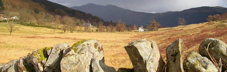
Timeline
Please explore our timeline by clicking on the dates or on the arrows.
This timeline shows a very small selection of events in local and Scottish history and prehistory.
Click on the links to find out more.
- Mesolithic
- Neolithic
- Rock Art
- Iron Age
- Romans
- Early Historic
- Iona
- Vikings
- 870
- 9th/10th Century
- Hogback stones
- Lewis Chessmen
- 1225
- 1263
- 1266
- 1314
- 16th century?
- 1600
- 1697
- 1733
- 1735
- 1745
- 1746
- 1747
- 1777
- 1784/1821
- 1821
- 1844
- 1860s
- 1880/1890
- 1900s
- 1945/1953
- 2010
Mesolithic
8000 BC – 4000 BC
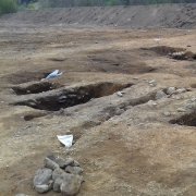
Some of the earliest evidence of human occupation in Scotland has been found on the island of Rum, in the Hebrides, where burnt hazelnut shells and signs of stone tools were discovered. However, a recent excavation at Succoth by Argyll Archaeology found charcoal and stone tools suggesting that people were visiting the area at the head of Loch Long as early as around 6000 BC.
Neolithic
4000 BC – 2500 BC
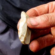
Skara Brae in Orkney has been described as the best-preserved Neolithic village in Northern Europe, with the remains of houses linked by covered passages and including stone furniture! Excavations in the school playing field in Tarbet uncovered over 50 pieces of worked flint, which, together with an earlier find of a small scatter of lithics near Arrochar, indicate Neolithic or Bronze Age activity in the area. A recent excavation at Succoth by Argyll Archaeology found evidence of occupation in the Early Neolithic period (around 3500 BC), including ditches with post holes, tools and charcoal.
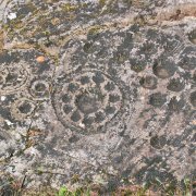
Cup and ring-marked stones
Cup and Ring-marked stones are found in lots of places in Scotland, with some of the best examples in Kilmartin Glen in Argyll. They might date from anywhere between 3500 to 1000 BC.
Iron Age
1000 BC – 500 AD
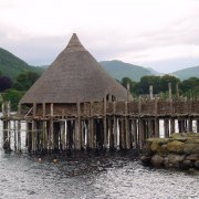
During the Iron Age, people in some parts of Scotland built huge round stone towers called brochs. These had no windows, and a single small door. A staircase wound up between the outside walls to the top. In other parts of Scotland, people built wooden houses on artificial islands called crannogs, like the reconstructed one on Loch Tay.
Romans
As the Romans tried to conquer Scotland, they built forts to house their soldiers and walls to help defend their conquered lands. They built wood and turf forts along the Gask Ridge in Perthshire, but the best known are along Hadrians’s Wall, which was started in 122 AD, and the Antonine Wall in 142 AD. As well as fighting with the local people, the Romans also traded with them. The Romans gradually retreated and had left Britain by 410 AD.
Dunadd
The hill fort on Dunadd is on a rocky outcrop rising out of the Mhoine Mhor near Kilmartin. It is thought to originally have been occupied in the Iron Age, but to later have become the seat of the kings of Dal Riata. Two stone footprints, an image of a boar and an ogham inscription are carved in the stone on top of Dunadd. It is mentioned in records from 683 AD and again in 736 AD.
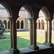
Iona
In AD 563, the Irish monk Columba and twelve followers set up a church and monastery on the Isle of Iona in the Inner Hebrides.
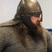
Vikings
Vikings raided Iona in 795 AD, and again in 802 and 806, killing monks and taking away gold and silver. Gradually though, the Norse began to settle in Scotland and merged with the local people. In the west of Scotland, in the Hebrides, the locals and the Norse became known as the Gall-Gael. Orkney and Shetland and the north of Scotland were dominated by the Norse for hundreds of years.
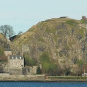
Siege of Dumbarton Rock
Olaf the White and his Viking army from Dublin laid siege to Dumbarton Rock. When the fortress’s well dried up, the Vikings broke in and plundered its treasure, and took many Britons away to Ireland as slaves. A Viking burial dating from around this time has been discovered at Boiden on Loch Lomond. It contained a sword that had been purposely bent, as well as a shield boss and a spear.
Midross Viking cemetery
Near to Boiden, a small cemetery, dated to the late 800s/early 900s A, was excavated at Midross. The graves included those of women and children, with grave good including whetstones, knives, a shale finger ring and a blue glass bead.
Viking hogback stones
Hogback stones are believed to be Viking grave markers. They have a curved ('hogbacked') ridge, often with outwardly curved sides, suggesting that they represent stylised 'houses' for the dead. A hogback stone in the churchyard at Luss has been dated to 11th century. It might have been moved into the churchyard from somewhere nearby. There is a wonderful collection of Hogback stones in Govan Old Church.
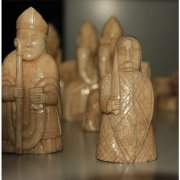
Lewis Chessmen
In 1831 a hoard of 12th-century chessmen was found in a stone cist in a sand-dune at Uig Bay, on the west coast of Lewis. The chessmen were carved in Norway from walrus ivory. The figures may have been buried here by a merchant who never returned to claim them.
Lands of Arrochar
Gilchrist, son of Alwyn 2nd Earl of Lennox, was granted 'de terris de superiori Arrochar de Luss' by his brother, Maldowen.
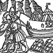
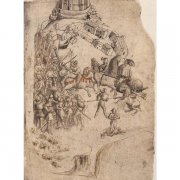
The Battle of Largs
In 1263 King Hakon sent forty ships up Loch Long to meet up with Magnus, King of Man. The Vikings pulled their ships out of the water and dragged them across the land to Loch Lomond, from where they sailed south to raid the settlements around the loch. After that, they rejoined the main fleet, and Hakon and his troops met with the Scots in the Battle of Largs. The result was inconclusive, but Hakon retreated to Orkney after the battle, where he died the following winter. The fact that the Vikings dragged their boat across the isthmus from Arrochar to Tarbet is recounted in The Saga of Haakon Haakonarson by Sturla Thortharson c. 1265. Click here for a translation (especially MCCLXII sections 12-14)
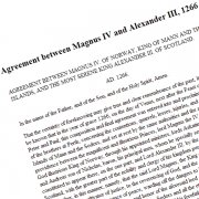
Treaty of Perth
The Treaty of Perth was signed by Hakon’s successor Magnus IV and Alexander III of Scotland in 1266. In return for four payments of 4,000 marks and a tribute of 100 marks in perpetuity, the Norwegians surrendered sovereignty over all the Western Islands and the Isle of Man, though they retained possession of Orkney and Shetland.
Battle of Bannockburn
On 23 and 24 June 1314, Robert the Bruce faced King Edward II at Bannockburn, near Stirling. The Scots army was outnumbered almost three to one, but despite this, the Scots were eventually victorious. Scottish independence was affirmed by the Declaration of Arbroath in 1320 and the Treaty of Edinburgh-Northampton in 1328.
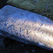
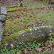
Ballyhennan graveslab
Most of the gravestones in Ballyhennan graveyard date from the 1700s, but one slab appears to be much older. It was discovered in part of the graveyard, probably in the 1970s, and moved to its current position - its original position isn't known. Several experts have examined the stone, but its date remains inconclusive, but possibly 16th century.
Clattochmore
The Chiefs of the Clan McFarlane are recorded as living in a thatched house at Clattochmore (Cladach Mhor, Clattach Mhor) in Tarbet during the reign of James VI.
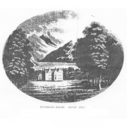
Inverioch House
Inverioch House was built by John McFarlane as the main seat of the MacFarlane’s. Although beside Loch Long, it faced towards Loch Lomond. Inverioch House later became Arrochar House, then the Cobbler Hotel, and now the Claymore Hotel.
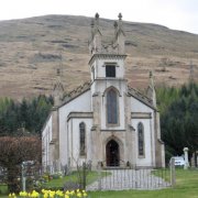
Arrochar Church
The first church in Arrochar was built in 1733 - until that time, parishioners had to travel to the church in Luss. The remains of the original church can still be seen in the churchyard. The existing church dates to 1847. Click on the link here for information on the gravestones at Arrochar Parish Church.
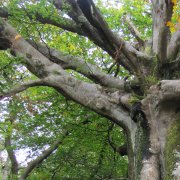
Tree planting
After building Inverioch House in 1697, the McFarlanes continued to develop the landscape around the house by planting trees, especially Scots Pine and Beech, probably for aesthetic as well as practical reasons. In a letter dated 1735, Walter McFarlane thanks Mungo Graeme for 'giving me some firs' and asks for 'a hundred or two of beeches' to plant along the avenue leading to the house. Tree-ring evidence suggests the tree-planting programme continued at least until the 1760s. The remnants of the plantations and tree-lined banks can still be seen today.
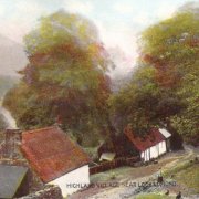
Tighvechtican
Edgar’s survey of 1745 provides the first record of a building at Tyvechtican, from the gaelic Tigh an Fhreiceadain, meaning House of the Watch, a reference to its use by the McFarlanes to watch for cattle to steal, or for approaching enemies. It stood at the junction of the old military road built in the mid-1700s and the entrance to a once tree-lined avenue leading to Inverioch House. Dorothy Wordworth described it as “…a beautiful spot…” in 1822, and as many as 15 people lived there in 1841. Unfortunately, the inhabitants fell on hard times, and two adjoining cottages were leased to the Parochial Board to house the ‘casual sick’ in 1887. A third cottage was finally abandoned in the 1940s.
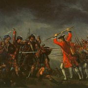
Battle of Culloden
On 16 April 1746, on Drummossie Moor overlooking Inverness, a well supplied Hanoverian army led by the Duke of Cumberland (son of King George II) annihilated the much smaller army of Prince Charles Edward Stuart led by Lord John Murray at the Battle of Culloden. This was the bloodiest of all the Jacobite battles and the last battle fought on British soil. Although the battle was over in an hour, more than a thousand Jacobites were killed and around 300 Hanoverians. The bloody aftermath went on for weeks, and ultimately led to the infamous Highland Clearances.
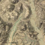
Roy's Military Survey
Roy’s Military Survey was prepared in the aftermath of the failed Jacobite rebellion to help Hanoverian troops to navigate their way around the Highlands. It shows an enclosure between Arrochar and Tarbet marked as ‘Killchenn’, probably associated with Ballyhennan graveyard. It also shows banks and/or ditches along the isthmus, and tree-lined roads and enclosures in Arrochar. Image reproduced by kind permission of The British Library Board.
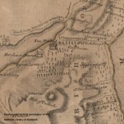
Ross' map
Charles Ross’ map from about 1777 depicts a large house at ‘New Tarbat’, now Arrochar, likely Inverioch House. Craggantarrish, Balfroine and Cloanreach are also noted, as is a 'Publick House' in Tarbet. Image reproduced by kind permission of the National Library of Scotland.
Sale of lands of Arrochar
In 1785, the last-named Chief of the MacFarlanes, John, sold the Arrochar estate to Ferguson of Raith for the sum of £28,000. It was later sold, in 1821, to Colquhoun of Luss for £78,000.
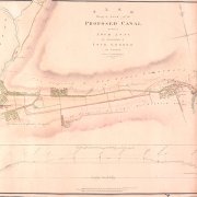
Proposed canal
In 1821, plans were drawn up for the construction of a canal to connect Loch Long with Loch Lomond. The proposed canal would have cut across the lands belonging to Sir James Colquhoun of Luss and John McMurrich Esquire. The canal was never constructed. Map reproduced by kind permission of Glasgow City Council Archives.
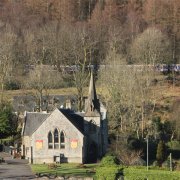
Ballyhennan Church
Ballyhennan Church was built as a Free Church in 1844, at a cost of £240. It ceased to be used as a church in 1966, and has since been used as a restaurant and craft shop.
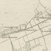
1st edition ordnance survey map
The 1st edition ordnance survey map of the area provides lots of information about the buildings and the layout of fields, as well as showing old place names. Creag an't Searraich (Craggantarrich) is shown to be in ruins when this map was produced.
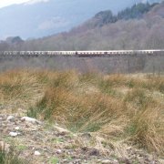
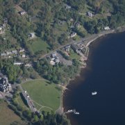
West Highland Line
Construction of the West Highland Line started in 1887 and it was finally opened in 1894. Arrochar and Tarbet station is situated midway between the two villages. The working conditions for the labourers were very poor, and 37 'navvies' died near Arrochar, Tarbet or Ardlui during its construction. They are buried just outside Ballyhennan graveyard, and a memorial to them was erected within the graveyard in 1994.
Golf Course
Arrochar and Tarbet Golf Club was formed in 1904 on land between the Tarbet Hotel and Ballyhennan Church, and remained in use until 1921. There were also two curling ponds - one opposite Ballyhennan Toll and one opposite the Tarbet Hotel, which was used by Hotel guests.
Ballyhennan Crescent
Building of the Loch Sloy Power Station started in April 1945, and it was opened by the then Queen in October 1950. The Hydro Board also built about 30 houses at Ballyhennan Crescent in 1949-1950, to house the staff of the power station.
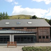
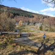
Three Villages Hall
In 2010, Arrochar and Tarbet Community Development Trust oversaw the successful completion of the Three Villages Hall in Arrochar. The Hall acts as a vibrant local hub for the three villages and also as a venue for the wider community.
Blog
Click on the link here to check out our Facebook page.
Events
Click here to find out about forthcoming events and how to get involved.
Timeline
Click here to see our timeline of events.
Location
Click here to find out where the Hidden Heritage Project is taking place.
Contact Us
Click here for our contact details.