
Tapestry
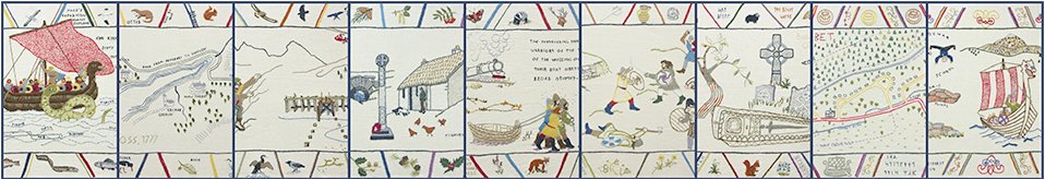
A group of local stitchers created a tapestry (well, strictly-speaking, it's an embroidery...) depicting the landscape of the isthmus from Arrochar to Tarbet, and some of its heritage sites and events.
The tapestry is embroidered on linen using crewel wool. It consists of nine separate panels, each 44 × 46 cm, designed to be hung side by side to represent a journey across the isthmus from Arrochar to Tarbet. The styles of the panels and the stitches used vary, but it has all been completed using a limited pallet of colours.
The panels were designed and drawn by Maureen Liddell and stitched by Maureen Liddell, Sue Black, Sue Furness, Chris Fowler, Joy Temple and Irene Wotherspoon.
Click on the images on the left to see the individual panels. The places and events that they depict are listed below:
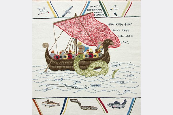
Panel 1: King Haco's Norwegian fleet enters Loch Long in 1263, as recorded in the Icelandic saga Haco's expedition against Scotland, A.D. MCCLXIII, by Sturla Þórðarson. The runes among the waves name men known to be on the ships. The torpedos under the waves recollect the torpedo testing range that operated on Loch Long from 1912 to 1986.
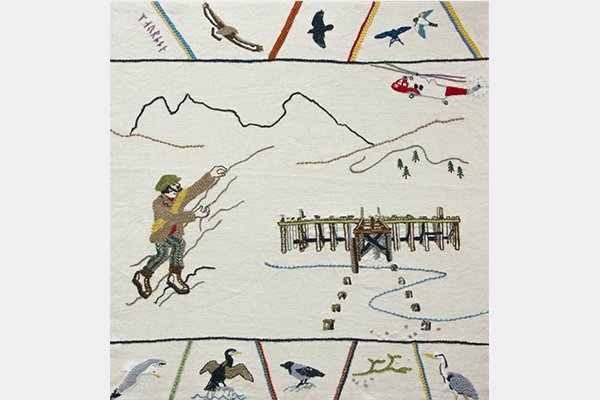
Panel 2: The outline of The Cobbler and the climber in his old-fashioned gear indicate the importance of the Arrochar Alps in the development of mountain climbing in the region, while the helicopter reflects the vital role played by Arrochar Mountain Rescue in ensuring the safety of climbers in the area. The now-derelict Arrochar Pier, once a busy stop for steamers, is now a favourite site for local seabirds to roost.
Panel 3: Based on A Map of the Shire of Dumbarton by Charles Ross, from about 1777. Note that Arrochar is called New Tarbat, and was the site of a large house, Inverioch House, built in 1697 by John MacFarlane. This site is now occupied by the Claymore Hotel.
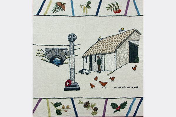
Panel 4: This depicts the bridge that forms part of the military road built by Major Caulfield's men around 1750 and one of the houses at Tighvechtican (the 'House of the Watch') where the Army Cadet Centre currently stands. The war memorial erected to the memories of local soldiers killed during the two World Wars is close by at the junction of the A82 and Church Road (the 'Back Road').
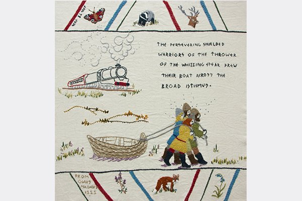
Panel 5: The isthmus between Arrochar and Tarbet was famously used by the Vikings of King Haco's fleet to drag their boats across in 1263. The same reasons that made it a useful route for the Vikings also made it a suitable route for the West Highland Railway, as well as for the main A83 and several paths.
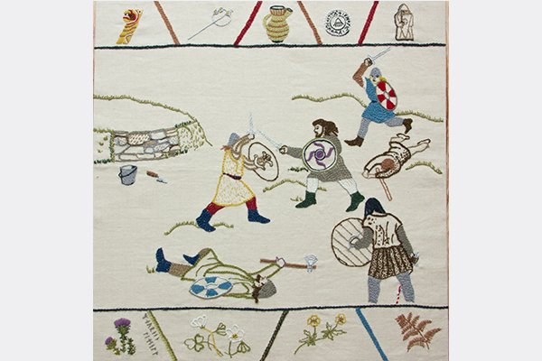
Panel 6: Local legend has it that the Vikings were attacked by the MacFarlanes on their way across the isthmus, and a skirmish ensued, resulting in the deaths of many Vikings. Unfortunately, there doesn't seem to be any documentary or archaeological evidence for this (so far)! The structure at the top left of this panel represents the circular feature located opposite Ballyhennan Church, and which was excavated as part of the Hidden Heritage Project. Its function remains a mystery, but it now seems clear that it was designed to keep animals out, rather than as an enclosure to keep them in!
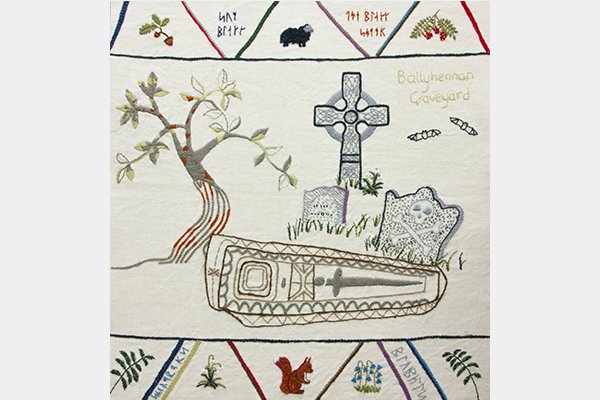
Panel 7: The small graveyard at Ballyhennan existed before there was any known church at the site. It's referred to as 'Kilchenn' on Roy's map from 1750. Although most of the gravestones date from the mid-1700s onwards, one enigmatic stone is much older and may date to the 1500s, suggesting that the graveyard itself might also be much older than originally thought.
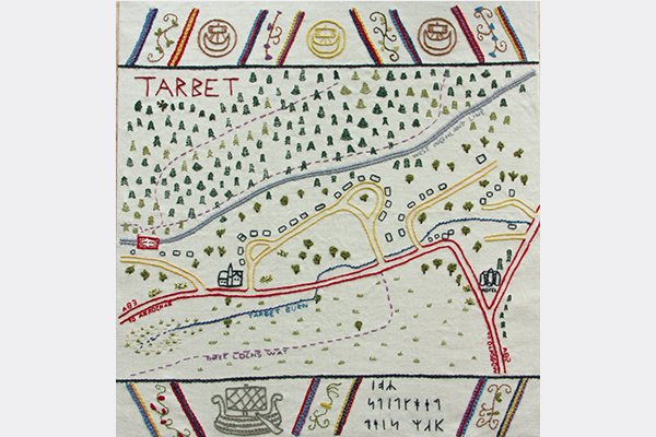
Panel 8: Based on the Ordnance Survey map, this shows the importance of the isthmus between Arrochar and Tarbet for communication routes: The A83 and the West Highland Railway both pass along it, as do several footpaths.
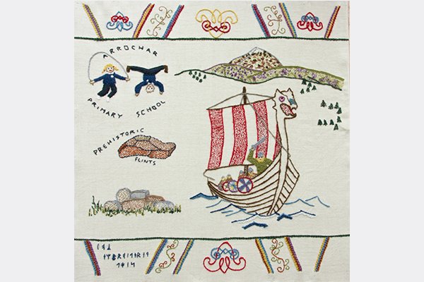
Panel 9: After dragging their boats across the isthmus, the Vikings re-launched them on Loch Lomond, going on to attack the islands, which they "...wasted with fire". Arrochar Primary School is situated on the banks of Loch Lomond, likely very close to where the Vikings put their boats into the Loch. Excavations across the road in the school playing field revealed an assemblage of worked flints, suggesting that prehistoric people were living nearby! A pile of stones reminds us that the chief of the MacFarlanes was reputed to have a house at Clattochmore in the 1500s, though excavations have so far failed to find it.
Blog
Click on the link here to check out our Facebook page.
Events
Click here to find out about forthcoming events and how to get involved.
Timeline
Click here to see our timeline of events.
Location
Click here to find out where the Hidden Heritage Project is taking place.
Contact Us
Click here for our contact details.